Trail Walking Le Syndicat - plaine cleurie - la bresse - Photo

plaine cleurie - la bresse

© OpenStreetMap contributors
Length
Length
23 km
Max alt
Max alt
1062 m
Uphill gradient
Uphill gradient
910 m
Km-Effort
Km-Effort  
36 km
Min alt
Min alt
438 m
Downhill gradient
Downhill gradient
981 m
Boucle
Boucle
No
Creation date :
2021-10-01 06:03:23.216
Updated on :
2021-10-04 13:48:28.564

(0 Reviews)

Walking
Walking
5h34
Difficulty : Very difficult

Scan this QR Code to open this trail in the SityTrail application

FREE GPS app for hiking

Logo SityTrail SityTrail

IGN / Geographical institutes

Download SityTrail from the App Store Download SityTrail from Google Play

Logo SityTrail SityTrail World

The world is yours!

Download SityTrail from the App Store Download SityTrail from Google Play Download SityTrail on Huawei AppGallery

About

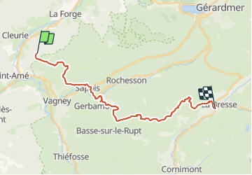
Trail Walking of 23 km to be discovered at Grand Est, Vosges, Le Syndicat. This trail is proposed by demange gerald.

Description

problème de mon GPS au départ: départ à Plaine-Cleurie (arrèt de bus), donc ajouter à cette rando 2.3 km et 225 m de dénivelé positif

Elevation profile

Photos

Positioning

Country:
France
Region :
Grand Est
Department/Province :
Vosges
Municipality :
Le Syndicat
Location:
Unknown
Start:(UTM)
328439 ; 5323304 (32U) N.

Trails nearby

Trail Walking Sapois - La Cascade de la Pissoire - Photo
Walking
tracegps

Walking

Medium
(2)
Sapois, Grand Est, Vosges, France
6.3 km | 8.9 km-effort
2h 0min
Yes
Trail Walking Saint-Amé - carrière de Saint Amé - Photo
Walking
EricMathieu

Walking

Medium
(1)
Saint-Amé, Grand Est, Vosges, France
8.6 km | 12.6 km-effort
2h 13min
Yes
Trail Walking Le Syndicat - Balcon du Solem - Photo
Walking
tracegps

Walking

Medium
(1)
Le Syndicat, Grand Est, Vosges, France
4.3 km | 7.4 km-effort
2h 0min
Yes
Trail Walking Sapois - La Cascade de la Pissoire - Photo
Walking
GUIDE
Desrumaux

Walking

Easy
(3)
Sapois, Grand Est, Vosges, France
6.3 km | 8.9 km-effort
1h 40min
Yes
Trail Walking Gerbamont - cascadu bouchot vosges - Photo
Walking
ghislaine61

Walking

Medium
(1)
Gerbamont, Grand Est, Vosges, France
7.9 km | 10.5 km-effort
2h 23min
Yes
Trail On foot Vagney - Circuit du Grisard - Photo
On foot
PRO

On foot

Easy
Vagney, Grand Est, Vosges, France
6.9 km | 9.8 km-effort
2h 13min
Yes
Trail Walking Saint-Étienne-lès-Remiremont - Les cuveaux à Eloyes - Photo
Walking
regish54

Walking

Easy
Saint-Étienne-lès-Remiremont, Grand Est, Vosges, France
4.5 km | 5.6 km-effort
1h 23min
No
Trail Walking Le Tholy - le trou d enfer - Photo
Walking
Didier-114

Walking

Easy
Le Tholy, Grand Est, Vosges, France
8.5 km | 12 km-effort
2h 45min
Yes
Trail Walking Sapois - Le haut du tot - Photo
Walking
JJG54

Walking

Difficult
Sapois, Grand Est, Vosges, France
19.4 km | 28 km-effort
4h 44min
Yes


Close
My subscriptions